Up ] [ Part Four ] Part Three ] Part Two ] Part One ] Introduction ]

Part Four - George Pemberton I of Cheshire, England and His Descendants

We believe the information given in Part Three above is sufficient to allow us the assumption that George Pemberton I and Sarah Middleton of Cheshire, England  were the parents of George Pemberton II who came to America in 1710 and settled in Virginia. As to his whereabouts prior to 1746, is still an open question although he might be the individual who purchased several properties in Hanover County or the one mentioned in Part 3 who purchased land from Charles Sneed.

George Pemberton II can be placed in Old Frederick County Virginia as early as June 1746 when he was awarded 25 pounds of tobacco for attending court in Winchester. This entry in the order books names one Jane Shepard who may have been a member of the Shepherd family who are considered the original settlers in the area now known as Jefferson County, West Virginia. 
      Later the court again acted on George's behalf granting him permission to clear a road from his dwelling to a road that ran from Dr. McCormick's to Capt. Rutherford's. It is this order that makes it possible to approximate the location of his land and that of Isaiah his son. Dr. McCormick owned a farm that had a corner fixed at a spring that is the source of the south branch of Bull Skin Run,a tributary of the Shenandoah River. The farm is still in existence today and is undergoing extensive restoration as a national landmark. It is unfortunate that we have no clear record of where Capt. Rutherford's was because he had so many grants for different properties in the area it is not possible to determine which was the one that the road led to. In 1750 Capt. Rutherford sold 453 acres to George Washington on Bull Skin Run but we can not be sure this was the property to which the road ran. George Washington also, later, purchased land adjacent to Dr. McCormick on the East side of Bullskin Run. He called his holdings in the area "Bullskin Plantation". 

      An additional source of information regarding George Pemberton's property may be found in Land Records for Northern Neck Virginia.

"The Northern Neck, or "Fairfax Proprietary," consisted of 5,282,000 acres located between the Rappahannock and Potomac Rivers. In 1649, King Charles II, then in exile, gave this unsettled region to seven loyal supporters, including Lord Fairfax. By 1688 most of the region was owned by Thomas, Lord Culpeper. Lord Culpeper's daughter married Thomas, Lord Fairfax, in 1690, and the region became synonymous
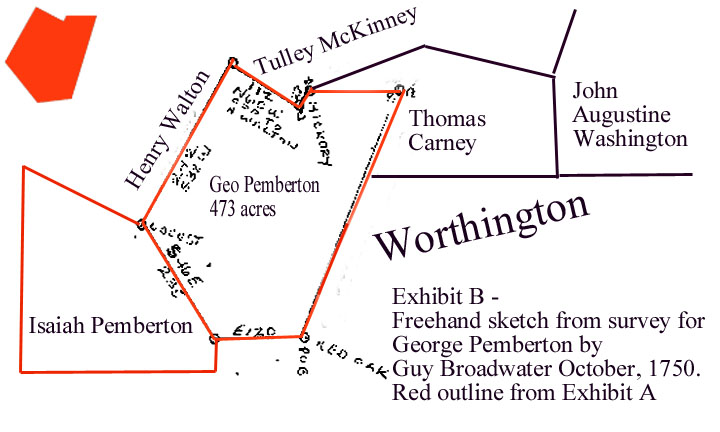
 with the Fairfax name.
Agents of the Northern Neck proprietors issued the first land grant in 1690. Individuals purchased warrants for a specified amount of land in a particular location. The warrants were taken to a surveyer and the land surveyed. The plat and any accompanying papers were returned to the proprietor's office, and a grant was issued. In an effort to halt land speculation, an order was issued by the proprietor's office on March 26, 1765, forbidding the assignment of warrants or surveys. The Northern Neck Land Office continued to operate during the Revolution until Lord Fairfax's death in 1782. Fairfax family interest was terminated in 1808 when the last surviving heir sold his title to a syndicate. Until 1862 land grants in the Northern Neck issued by the commonwealth of Virginia were recorded in volumes maintained separately from the regular Land Office grants." [6]

    These records give additional clues to the location of the property and who owned adjacent properties. To begin with Mr. Guy Broadwater recieved an order to survey two properties for George Pemberton together with a note from George Washington.

"Pg 120 Vol 2 -  George Pemberton, 10 Apr 1750 - survd not dated, 473 a. where he lives, Adjacent To:Worthington's pat., Tully McCenney, Henry Walton.  Chain Carriers - Henry Bradshaw &Thos Carney (?).  Surv. Guy Broadwater. 
3 Oct. 1750 - An order from Mr Washington to charge this plat & his son Isaiah's (Pemberton) to his account. 
Isiah Pemberton, no wart, survd., not dated 542 a. Adjacent To: Worthenton, Geo Pemberton, Henry Walton.  Chain Carriers - Henry Bradshaw & Carney,  Surv. Guy Broadwater," [7]

        Subsequently two grants were issued one to George on 15 Oct 1750 and to Isaiah on 16 Oct 1750. The grant for Isaiah was issued to "______ Pemberton" for reasons unknown but the above survey information proves that he was the intended recipient. 
        Later George Washington surveyed the property adjacent to George Pemberton for Thomas Carney who acted as a chain carrier above. Carney received his grant on 23 Oct. 1754. Carney's plot was also adjacent to John Augustine Washington brother to George. Adjacent landowner Robert Worthington was a large landholder in the area and a witness to George Pemberton's will in 1756. Robert purchased an additional tract  adjacent to the Pembertons on 31 Dec 1751 that mentions a "wagon road" but there were several old wagon roads in the county. 
         Although there can be little doubt the Pemberton properties lay in what became Jefferson County, WV it was not possible to pinpoint their exact location. Fortunately based on a map found on the website: "The Washington's of Jefferson County" and a drawing based on Mr. Broadwater's surveys we have been able to locate them.


First look at the red area on the map from the website:

PEMBERTON A.jpg (94427 bytes)

(Click map to enlarge.)
 

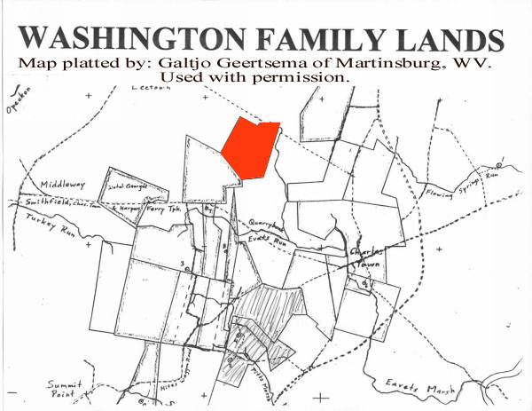
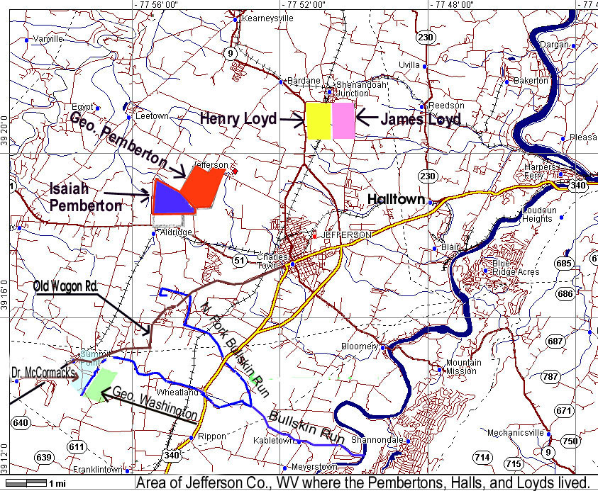
Next look at this free-hand drawing made from surveys by Guy Broadwater and George Washington:

PEMBERTON B.jpg (94908 bytes)
(Click map to enlarge.)

You can see that the drawing matches the map perfectly which now makes it possible for us to show on a modern map the locations of both properties, also Dr. McCormick's, Halltown and others. The Loyd property locations were given us by Mr. Stuart Lloyd of New Jersey.

PEMBERTON C.jpg (398112 bytes)

(Click map to enlarge)

George Pemberton's will written in 1756 is perhaps the most important document we have for this period in his life. In it he leaves his property to son George of 422 acres, Isaiah having already received his share of the property previously. The brothers sold their interests to Samuel Washington in 1771, which explains why they were included in the map of Washington land above.

"The information I have on the the lands of George and Isaiah are copies  of the Deeds whereby both men with their wives Elizabeth (Isaiah) and  Judith (George) and both to Samuel Washington of 542 acres for Isaiah  and 473 acres for George on 1/27 and 1/28/1771 (for Isaiah) for 5  shillings and 435 pounds and 2/1 and 2/2/1771 for George for 5 shillings  and 300 pounds.  Both Deeds indicate the land joined Robert  Worthington's land patent 10-2-1735 and being tract granted to Isaiah  and George separately by a Deed from Lord Fairfaxe dated 10-16-1750 (for  Isaiah) and 10-15-1750 (for George).  My records show that Isaiah was married in 1752 and George ABT 1755.  Which means both men were single in 1750." [9]        

             Children listed in the will were:

                            George who married Judith Brooks
                             Isaiah who married Elizabeth Hall
                             Judi who married Henry Lloyd
                             Ann who married Charles Sneed
                             Sarah  who married Thomas Carney
To learn more about any of the children click the link to our World Connect site.


1. Order Books Frederick Co., Virginia (GEDCOM FILE: Ancestry.com File # 40200, Submitter mmmatheny@ecampus.com ). 

"Frederick Co., VA...JUNE, 1746...It is ordered that Jane Shepard pay George Pemberton twenty-five pounds of tobacco for attending one day as evidence for her agent, John Smith.
..P. 290 ...on the petition of George Pemberton, it is ordered that he have liberty to lay off and clear a road from his dwelling house to the road that leads from Captain Rutherford's to Doctor McCormack's."


2. The History of West Virginia, Old and New. (Published 1923, The American Historical Society, Inc.,Chicago and New York), Volume II. pg. 187
Posted to the Web at: http://searches.rootsweb.com/cgi-bin/ifetch2?/u1/data/wv+index+580766158902+F

"The pioneer family in the Shenandoah Valley was Thomas Shepherd, a son of William Shepherd and grandson of Thomas Shepherd.  The grandfather died in Maryland in 1698, and was probably one of three brothers who came from Wales to America in early Colonial times.  Thomas Shepherd, the founder of Shepherdstown, was born in 1705, and died in 1776.  About 1730 he received a land grant from King George the second, comprising 222 acres south of the Shenandoah River.  He settled in that locality in 1732, and was founder of the community first known as Mecklenberg and later called Shepherdstown.  A state law of 1765 established a ferry on the land of Thomas Shepherd at Mecklenberg over the Potomac. Thomas Shepherd married Elizabeth Van Metre, daughter of John Van Metre, the Indian trader.  She died at Shepherdstown about 1792.  They had a large family of children, several of whom settled and lived around Wheeling, West Virginia."


3. The Evolution of Jefferson Co., WV:
Jefferson County was formed in 1801 from Berkeley County, Virginia
Berkeley County was formed from Frederick County, Virginia, in 1772
Frederick County, formed in 1743 from Orange County
Orange County was formed in 1734 from Spotsylvania County
Spotsylvania County was formed from Essex, King & Queen and King William Counties in 1721

Jefferson Co. became part of West Virginia during the Civil War.


4. White House Farm - by Curt Mason, (posted to the web at: http://www.geocities.com/cmasonnos/whitehousefarm.html )

On June 17, 1730, John and Isaac VanMeter petitioned the Virginia Colony Council for 40,000 acres in the Shenandoah Valley.  In 1731 they transferred 30,000 acres to Jost Hite, a German immigrant, under a patent.  The land, then  located in Orange County, Virginia, (see 1734 map below) was surveyed by Robert Brooke on 26 March 1734.   In May 1740, Mr. Hite sold 395 acres to Dr. John McCormick, a Scots-Irishman, for 8 pounds,  5 shillings.
     By 1742, Dr. McCormick had built a three-story, two-room farmhouse. Dr. McCormick was a prosperous and prominent country doctor, as evidenced by the inventory of his estate completed upon his death in 1768.  His will and the administrations are found in the Frederick County archives in Winchester, VA, since Frederick County was formed in 1743.
   He and his wife Ann had 6 sons (James, Francis, John Jr., William, George, and Andrew) and two daughters (Mary, wife of Magnus Tate, and Jean, wife of James Byrn).  James served as the chain carrier and John Jr. as the pilot on several of George Washington's surveys (1), and in 1752 George surveyed the farm itself.  White House Farm was noted for the horses bred there during Dr. McCormick's lifetime.(2)
    References:
    (1) The George Washington Papers, Library of Congress
    (2) Virginia Magazine of History and Biography, published by  the Virginia Historical Society
     Acknowledgement: 
Ann Shoemaker, Andrew McCormick's great-great-great-great-grand-daughter contributed information to this history.

[This is a very interesting website created by Mr. Curt Mason the caretaker at: White House Farm. This site includes a detailed history, photographs, woodcuts, and even music. A must visit for anyone interested in the Jefferson County area.]


5. The Washingtons of Jefferson County - (posted to the web at: http://www.lib.shepherdstown.wv.us/huntfield/documents.html

Oct. 20, 1750 - Frederick County, VA. - George Washington is the second member of the Washington family to purchase land in Jefferson County, buying 453 acres along the lower fork of the Bullskin from Thomas Rutherford.

"Survey'd for myself the land at the head of the Marsh which I bought of Captn Rutherford and afterward granted to Lord Fairfax." (Ibid, P. 26 and GW's Survey Field Book, 1750-1, P. 16 Library of Congress).

6. Virginia Land Office Patents and Grants and Northern Neck Grants and Surveys - (posted to the Web at:
http://lvaimage.lib.va.us:8000/bibdatabases/lonnabout.html#top )

7. Joyner, Peggy S., comp. Abstracts of Virginia's Northern Neck Warrants & Surveys. 5 vols. Portsmouth, Va.: P. Joyner, 1985–1987. Vol II

8. Virginia Land Office Patents and Grants and Northern Neck Grants and Surveys - (posted to the Web at:
http://lvaimage.lib.va.us:8000/bibdatabases/lonnabout.html#top )

Carney, Thomas. grantee., 23 October 1754,  Frederick County,  238 acres adjoining Robert Worthington, George Pemberton, Tully McKenny &c. Source: Northern Neck Grants H, p. 506 (Reel 293).
Survey by George Washington: "March 10th - 1750-1  Then Survey'd for Thomas Carney a certain tract of land Beg at our oak marker I9 corner to Mr. John Graham also corner to Mr. Augustine Washington and extended thence with this (0) Washington's line South 162 poles to 2 small and Oak saplens in Robt. Worthington's Line thence with his
line j N by W. 150 poles opposite to Worhingtons corner to ye right in George Pembertons line thence N 10' W (?) 134 poles to Pembertons corner about 2 poles to ye right hand 3 angular hicory thence with another of his lines West 120 poles to a black oak and hicory his corner in Tully McKenny's line thence with his line N 90 degrees E. 196 poles to a white oak corner to Tully McKenny thence SE 106 poles to the Beg Containing 230 acres 
Robt Worthington) CC   Plat drawn
Henry Walton    )              Thomas Carney Mr. (Marker)"

Worthington, Robert. grantee., 31 December 1751,  Frederick County,  526 acres adjoining George Pemberton and near the Old Wagon Road,  Northern Neck Grants H, p. 73 (Reel 293).

9. E.L. Pemberton, Family Notes, 16 May 2000.